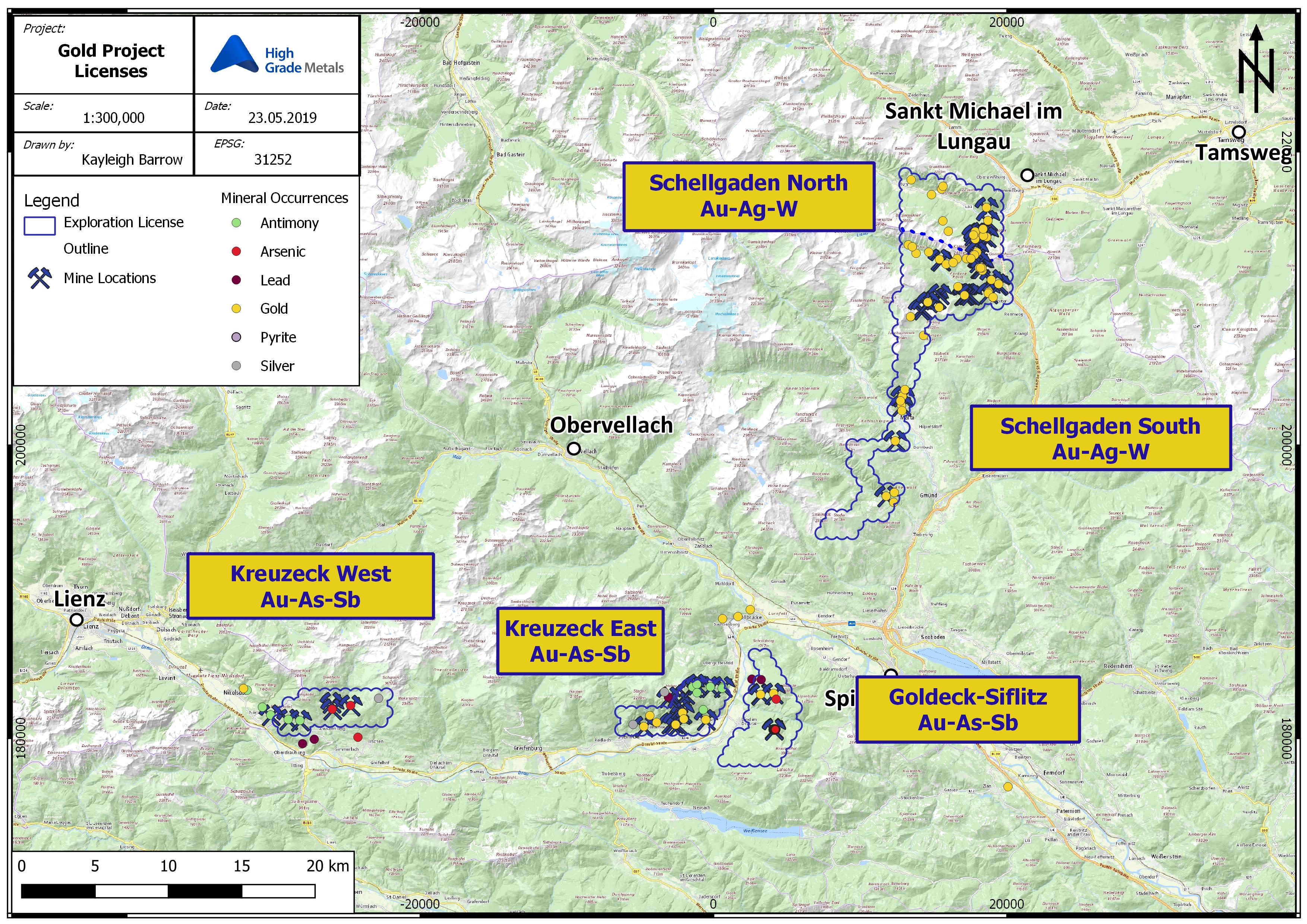
Project Overview - Gold
Each of High Grade Metals’ Gold Projects lies in south-central Austria, within or immediately south east to the Tauern Window.
All project areas are historically known to host precious metals, with roughly 80 gold ‘occurrences’ recorded on the Austrian mineral database ‘MinDat’, over 50 known and identified mines and hundreds of further unrecorded adits, dating as far back as pre-Roman times.
Schellgaden North and South are located in the Schellgaden Mining District which geologically extends along the eastern rim of the Tauern Window, from the upper Mur Valley in the north, to south of the town of Gmünd in Carinthia. The 2 project areas are divided by the Carinthia/Salzburg state boundary, but are considered as one area for ease of reference.
Schellgaden gold occurrences occur almost exclusively within the Kareck-Storz Series, a roughly 1000m thick, ore-bearing unit belonging to the Habach Formatin, located on the eastern edge of the Tauern Window.
The remaining three Gold Projects (Goldeck-Siflitz, Kreuzeck East and Kreuzeck West), lie within the Goldeck-Kreuzeck Mining District located within the Kreuzeck Group Mountains, a range which extends east-west for more than 40 km. The Kreuzeck Group Mountain range is seperated from the Mesozic Drau Range to the South by the E-W trending Drau Valley Fault, and from the Tauern Window to the North, by the NW-SE striking Mölltal Fault.
| Project Name | No. of Concessions | Area km2 |
Major Mining Districts | Mineralisation |
| Schellgaden North | 68 | 31 |
Stüblbau, Schulterbau, Knappenstube, Ramsbacher Bau, Birgeck, Jagerhalte
|
Au hosted in bedding parallel, quartzitic ‘layers’ of the Kareck-Storz Series |
| Schellgaden South |
151
|
69 | Goslitzen, Oberdorf, Millionenloch, Silberloch, Dornbach, Radlgraben | Au hosted in bedding parallel, quartzitic ‘layers’ of the Kareck-Storz Series |
| Goldeck-Siflitz |
57
|
27.6 | Guginock, Vorder-Siflitz, Weißwände | Auriferous Arsenopyrite in silicified fault zones |
| Kreuzeck East |
42
|
20.5 | Gerlamoos, Lengholz, Pragen, Stottergraben |
Auriferous Arsenopyrite in grayish/black ‘greasy’ Quartz veins / Stratiform massive Stibnite
|
| Kreuzeck West | 44 | 23.9 | Fundkfel, Strieden, Gurskerkammer, Rabant | Strata-bound syngenetic ore layers of complex Massive Sulphides contained in thick packages of quartzitic Micaschist |
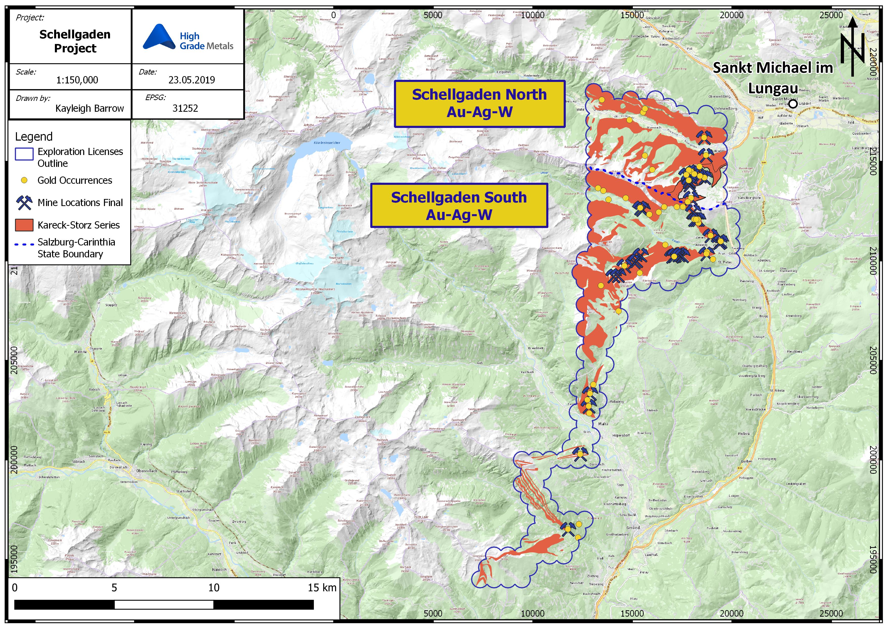

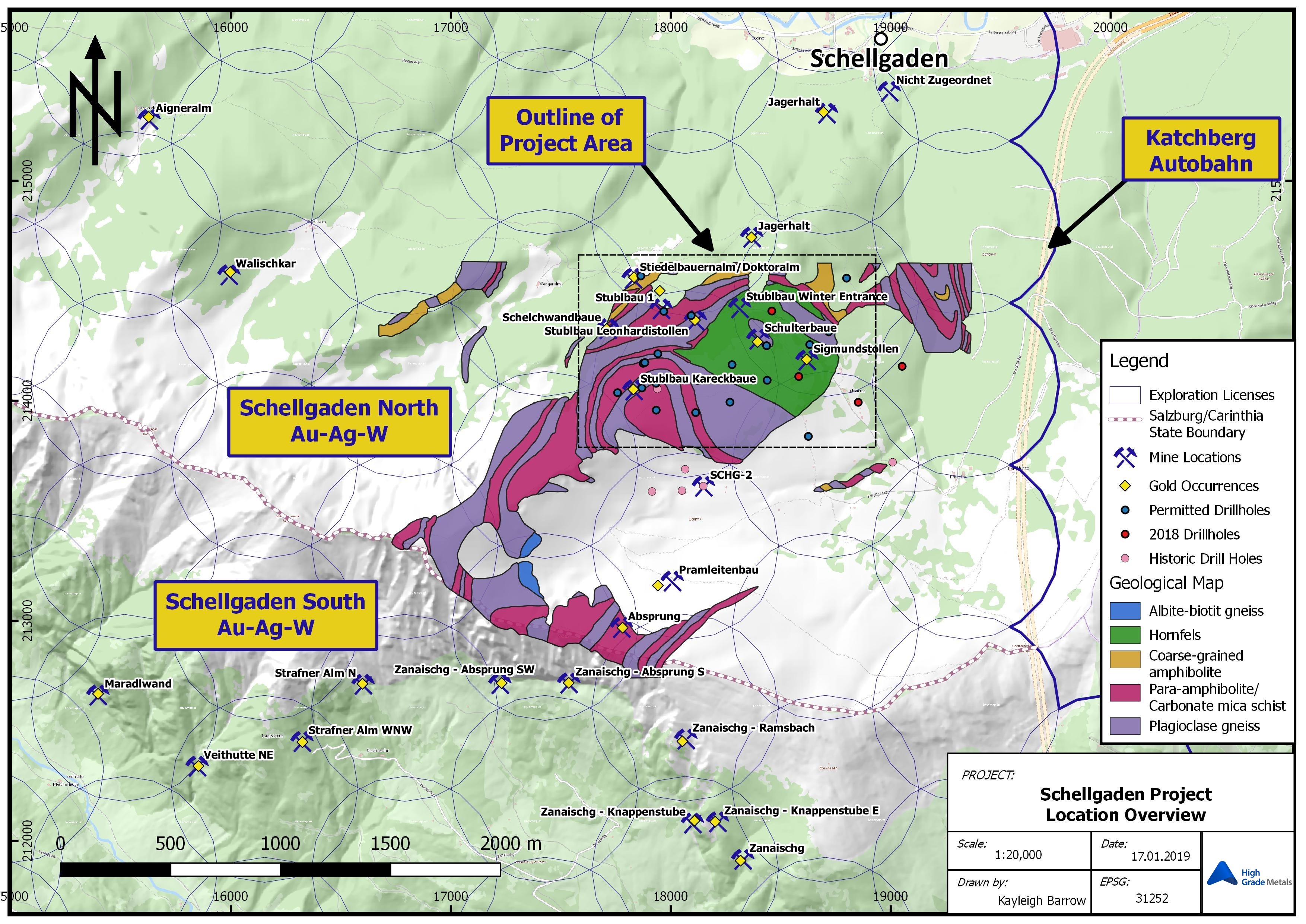
Schellgaden Gold Project
The Schellgaden Project covers an area of approximately 100km2 and can be divided into two exploration regions:
- Schellgaden North, located within the state of Salzburg, comprises of 36 exploration concessions and has been considered one of the richest and most active gold mining districts in Austria, and includes the well known mines of Stublbau and Schulterbau
- Schellgaden South, located within the state of Carinthia, comprises 121 exploration concessions, and although considered less explored, the region still holds claim to many historic gold mines.
Apart from the known mine survey undertaken by VOEST Alpine Steel in the 1980’s, which was designed to focus on scheelite occurrences within the old mines, little is known of the exploration efforts in the area prior to the Canadian company, Argosy Mining Corp, acquiring the Schellgaden tenement holdings in 1995 through its Salzburg based subsidiary (‘AMG’).
In May-June 1995, AMG undertook systematic geochemical sampling of accessible stope faces in a number of historic mines in Schellgaden North & South. From a total of 133 channel samples, geochemical analyses, of gold and 34 other elements, provided the first modern evaluation of the Schellgaden ore bearing layers. Channel samples collected by AMG revealed average gold grades of 7,508 ppb to 10,012 ppb (7.5 – 10.0 g/t) for the Barbara Lager in the Stüblbau Mine and average grades of 8,352 (8.3 g/t) in the Schulterbau Mine. Peak assay results of nearly 1 oz/t (34,280 ppb) where recorded in the nearby Knappenstube East Mine.
In October 2018, High Grade Metals undertook a maiden drill program at Schellgaden, with focus around the historic, high grade, Stüblbau mine. The initial drilling was designed to consist of 4 – 6 diamond holes drilled from state approved sites. The drill holes were prioritized based upon a variety of factors including logistical, geological and time issues, in addition to the performance/capability of the drilling contractor. The planned program was designed to focus on the geological connections between the existing mine, and the Katschberg transport tunnel.
Four diamond holes were completed in a programme lasting almost six weeks; SCH18-10, SCH18-13, SCH18-18 and SCH18-19 (Table 1). Of these four drill holes only one drill was drilled to its planned of 300 m, namely SCH18-18. Table 1 lists details of each of the four holes completed in the 2018 drilling programme.


| Hole ID | Date Started | Date Completed | Easting (mE) |
Northing (mN) |
RL (ASL) |
Planned Depth (m) |
Actual Depth (m) |
Azimuth | Dip | Contractor | HQ (m) | NWT (m) |
| SCH18-10 | 09/11/2018 | 23/11/2018 | 391853 | 5213756 | 1828 | 300 | 235.85 | 000º | -90º | Energold | 0.00 to 148.65 | 148.65 to 235.8 |
| SCH18-13 | 08/11/2018 | 24/11/2018 | 391969 | 5213456 | 1853 | 300 | 259.50 | 000º | -90º | Energold | 0.00 to 145.50 | 145.50 to 259.50 |
| SCH18-18 | 19/10/2018 | 08/11/2018 | 392237 | 5213333 | 1740 | 300300 | 000º | -90º | Energold | 0.00 to 156.90 | 156.92 to 300.00 | |
| SCH18-19 | 24/10/2018 | 09/11/2018 | 392440 | 5213492 | 1640 | 300 | 277.45 | 000º | -90º | Energold | 0.00 to 187.65 | 187.65 to 277.45 |
Goldeck-Siflitz Project
The Goldeck Siflitz Project is located immediately East of the Drau River Valley, 2km south of High Grade Metals core storage facilities at Mollbrucke. The license area is comprised of 37 exploration concessions, covering an area of approximately 27km2.
A large number of ore occurrences (Sb, Hg, Au, Ag, Cu, Pb, Zn, W) have been mined within the Goldeck-Kreuzeck mountain ranges. This is due to a massive tectonic fault-shear and over-thrust zones which were continually exploited for gold and antimony at the Guginock and Siflitz districts. The 1920s explorations at Guginock discovered a significantly mineralised system, two generations of arsenopyrite, gold and traces of base metal sulphides at grades from about 3 to 20 g/t Au. Re-sampling by BBU in the 1970s gave values ranging from 4.8 to 18.2 g/t Au, averaging 12 g/t Au.
In 1995, Canadian company Argosy Mining Corp has since undertaken exploration work at the Guginock prospect. This work included: Geological/structural mapping of the Guginock drift; 22 channel samples which grading between 0.5g/t and 12.1 g/t Au; Geological mapping over a 7km2 area immediately south of the Siflitz Graben; and three 100m directional drillholes (GU1, GU2, GU3) immediately west and east of the Wallner stollen, 30m above the Guginock drift entrance. One of the drillholes, GU-1 intersected an interval of 9m at 6.2g/t.
This project is not the primary focus of the Company’s immediate exploration program, but will be systematically explored over the next 5 years.

Kreuzeck East Project
The Kreuzeck East Project covers the southern slopes of the eastern Kreuzeck Mountains, between Steinfeld in the west and Lessnig in the east, in southwestern Carinthia. The Kreuzeck East Project lies within an Exploration Permit, comprising 42 Freischurfe, which encompasses a total area of approximately 20.5 km² and includes two famous old mining districts; the very rich historic mines of Lengholz and the stibnite deposits of Lessnig-Radlberg.
Gold was discovered in 1544 in Lengholz and by the time this mining site was abandoned, in the 17th Century, some 15 galleries were reported to have been mined. In contrast, the Lessnig-Radlberg locality was mined later, from the 18th to the beginning of the 20th centuries, and for stibnite. Because of its proximity the local geology is very much an extension of that found in the adjacent Goldeck-Siflitz. The distinct differences in mineralisation between Lessnig-Radlberg and Lengholz suggest a detailed structural analysis, including analysis of possible stock-work related structures and vertical zonation will need to be undertaken. This project is not the primary focus of the Company’s immediate exploration program, but will be systematically explored over the next 5 years.
Kreuzeck West Project
The Kreuzeck West Project is located in Goldeck-Kreuzeck Mining District, in between Nörsach-East Tyrol and Irschen, north of the Drau Valley. The Project includes four significant historical mines; Rabant, Gurskerkammer, Fundkofel, and Knappenstube-Strieden.
The Kreuzeck West Project lies within an Exploration Permit, comprising 44 Freischurfe, which encompasses a total area of approximately 23.9km2.
Previous mining activities suggest a trend, or zoning, from predominantly stibnite ore bodies (such as encountered in the Rabant Mine) to stibnite and arsenopyrite-gold (such as encountered in the Gurskerkammer Mine) to gold (& silver) in the east (such as encountered in the Fundkofel Mine). Gold at the Fundkofel Mine is mostly bound to arsenopyrite, in ore shoots limited to a “greenstone” belt.
The Rabant-area stibnite ore bodies, with their lenticular to layer like shapes, are interpreted as stratiform, as is the Gurskerkammer Mine’s stibnite and arsenopyrite-gold mineralisation, whereas the Fundkofel Mine gold mineralisation is related to vein like, discordant structures suggesting an hydrothermal origin.
The Strieden-Knappenstube mineralisation is strata-bound and an earlier SP geophysical survey, together with soil geochemistry purportedly indicated a potential 3.6 km long mineralized sulphide belt.
At the Fundkofel Mine the average gold grade calculated from channel samples taken over 1 metre sample intervals of all exposed ore is 14.7 g/t Au (6.6 g/t Ag). The past geological and structural surveys at the area surrounding the mine are supportive of a much larger mineralized area.
This project is not the primary focus of the Company’s immediate exploration program, but will be systematically explored over the next 5 years.